

Lawrence Wager and the Geology of Mt Everest
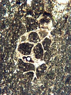
Lawrence Wager (Professor of Geology and head of this Department 1950–1965) participated in the 1933 British attempt to climb Mt Everest. Together he and P Wyn Harris reached 8573m on the NE Ridge, above where Mallory and Irvine were last seen in 1924, and less than 300m below the summit. On the approaches and on the ascent he made a collection of over 200 rock samples, now kept in the Oxford University Museum of Natural History. In recent years Oxford geologists have returned to the Everest area as part of a project on the tectonics and petrology of the Himalayan chain led by Professor Mike Searle.

An extract from the geological map of the Everest area by M P Searle. It shows Mt Everest and neighbouring peaks capped by sedimentary limestone and underlain by low grade metasedimentary rocks (Yellow Band and Everest Series). These in turn pass down into granite, migmatites (alternations of granite and schist) and high-grade metamorphic gneisses in the valley floors and to the south.
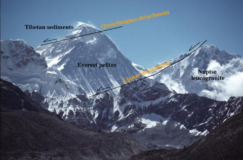
Running the full length of the Himalayan chain is a thick slab of metamorphic rock, the Greater Himalayan Series, which formed in the mid-crust at an earlier stage of the evolving collision between India and Asia. Its appearance at the surface today is the result of movement on two spectacular shallow-dipping fault systems: at the base of the slab, the Main Central Thrust zone, and at the top, the extensional faults of the South Tibetan Detachment System (STDS). Along much of the Himalaya, sediments rest almost directly on high-grade gneiss across the STDS, but in the Everest area there is an intervening unit of lower-grade schists that offers a vital insight into how the top of the slab developed. Unfortunately, as the photo indicates, these are mostly exposed in near-vertical faces at extreme altitude, and good samples are few.
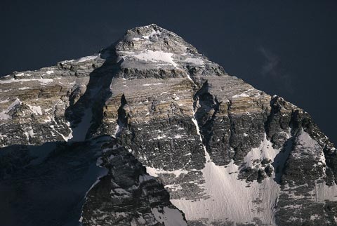
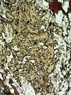
The upper part of Mt Everest is seen here from the north. The topmost strata are grey limestones that in places contain fossil fragments. Wager’s highest sample is of this limestone, from just below the NE ridge at the left-hand side of the photograph. Below this is the so-called Yellow Band, made of pale yellow-brown metamorphosed limestone. The break in metamorphic grade here marks the position of an important low-angle extensional fault – the Qomolangma Detachment. Beneath the Yellow Band are the black schists of the Everest Series. Petrological study of Wager’s samples has shown that metamorphic temperatures reached 450°C at the base of the Yellow Band.
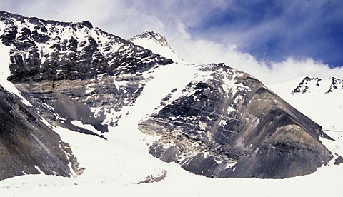
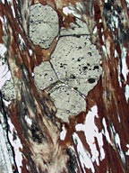
These outcrops above the East Rongbuk Glacier, opposite the northern Advance Base Camp, show the lower parts of the Everest Series. At the bottom they are intruded by veins and sheets of granite, marking the transition into the high-grade gneisses of the Greater Himalayan Series. Wager’s samples from the right-hand ridge reached their metamorphic peak at 650°C at a pressure of 6 kilobars (about 22km depth in the crust). They now lie only 2000m below the essentially unmetamorphosed summit limestones, because of the action of the Qomolangma Detachment.
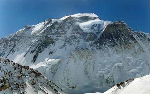
The mountain Gyachung Kang, 20km to the north-west, shows the same sequence of rock units as Everest. From the top: limestone (mostly snow-covered), Yellow Band, Everest Series schists, a thick sheet of pale granite, and darker sillimanite gneisses just visible at the base of the cliffs. Note here, however, the very sharp horizontal boundary between the dark Everest Series schists and the granite. It has been suggested that there is another extensional fault at this level, the Lhotse Detachment.
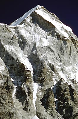
Wager, as an igneous petrologist, was particularly interested in the sheets of pale leucogranite (granite with very few dark minerals), many of which run for long distances parallel to the layering in the schists and gneisses. In the Everest area some of these sheets are very thick, like this one (below, left) forming the south face of Lingtren, a few km WNW of Everest. Below the granite can be seen brown-weathering high-grade gneisses of the Greater Himalayan Series.
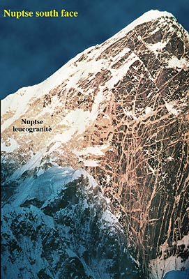
In some places the intrusive relationships of the granites (above right) are more obvious. The larger mass of granite underlying the southern part of the Everest massif has sent out a tangle of cross-cutting veins into the dark country rock of the south face of Nuptse.
Credits
Adapted from a display poster in the Department of Earth Sciences, Oxford.
Field photos: Mike Searle
Photomicrographs: Dave Waters
Text: Dave Waters
Production and layout (original poster): Dave Sansom and Dave Waters