| Home | Geological History | Stratigraphy | Area map | Rock Index | About |
| Scourie | Achmelvich | Laxford | Clachtoll | Stoer | Assynt | Skiag Bridge | Glencoul | Knockan | Borralan | Ledmore |

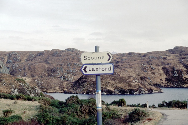
![]() Lewisian landscape just north of Scourie. Turn right for
the oldest high-grade metamorphic rocks. Turn left for
rocks deformed and heated again in the later Laxfordian
episode.
Lewisian landscape just north of Scourie. Turn right for
the oldest high-grade metamorphic rocks. Turn left for
rocks deformed and heated again in the later Laxfordian
episode.
Around Scourie village you can study the early history of the Lewisian Complex. Rocks like these probably make up much of the lower continental crust of the Earth. The original igneous rocks were produced by melting in the Earth's mantle. The melts rose as magmas and crystallized at shallower levels, building up the crust. Later these new rocks were folded and heated, and further magmas were intruded during the metamorphism, so that now almost all the rocks are gneisses.
Several rock types are found in the Lewisian Complex. They can be broadly subdivided into felsic gneisses (rich in light-coloured minerals like feldspar and quartz), mafic gneisses (containing a large proportion of dark mafic minerals such as pyroxene, hornblende, or biotite mica), and ultramafic gneisses (containing exclusively mafic minerals). Generally speaking, felsic gneisses form from igneous rocks of acid composition, mafic gneisses from basic igneous rocks. The felsic gneisses are the most abundant, and are the metamorphosed equivalents of granite or, more characteristically, tonalite (like granite but without potassium feldspar). Mafic and ultramafic gneisses are generally found together in this part of the Lewisian Complex, and can be understood as metamorphosed varieties of gabbro and peridotite.
The intensity of metamorphism is assessed from the sets of minerals found together in a metamorphic rock. Geologists use the term grade to describe the overall intensity of metamorphism, which mainly depends on the highest temperature reached. Low grade metamorphic rocks are rich in minerals of high water content (micas and other sheet silicates, amphiboles) and are commonly fine grained or poorly recrystallized, so that the texture of the previous rock can still be seen. High grade metamorphic rocks like those of the Lewisian Complex, on the other hand, are coarse grained, thoroughly reconstituted rocks, and most of their minerals contain no water. An important distinction in the Lewisian Complex is that the early Scourian metamorphic event was of high grade (where the typical mafic mineral is pyroxene), whereas the later Laxfordian metamorphism was of medium grade (typical mafic mineral is hornblende).

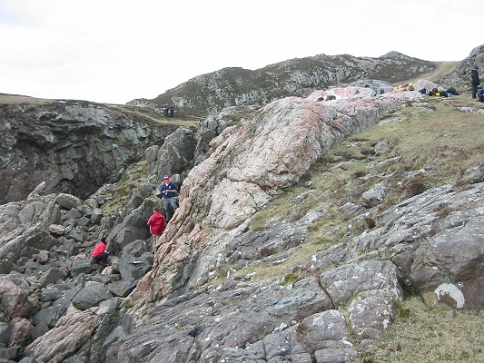
![]() At this locality on the south side of the Scouriemore
peninsula, mafic and ultramafic gneisses (dark rocks) are
sandwiched between felsic gneisses (left, and in the
distance), and cut by an irregular-shaped intrusion of pale
pink pegmatite. Radiometric dating of the mafic and
ultramafic rocks gives an age around 2700 million years,
which can be interpreted as the time the original igneous
rocks were intruded. The intrusion of the pegmatite has
been dated at 2500 million years.
At this locality on the south side of the Scouriemore
peninsula, mafic and ultramafic gneisses (dark rocks) are
sandwiched between felsic gneisses (left, and in the
distance), and cut by an irregular-shaped intrusion of pale
pink pegmatite. Radiometric dating of the mafic and
ultramafic rocks gives an age around 2700 million years,
which can be interpreted as the time the original igneous
rocks were intruded. The intrusion of the pegmatite has
been dated at 2500 million years.

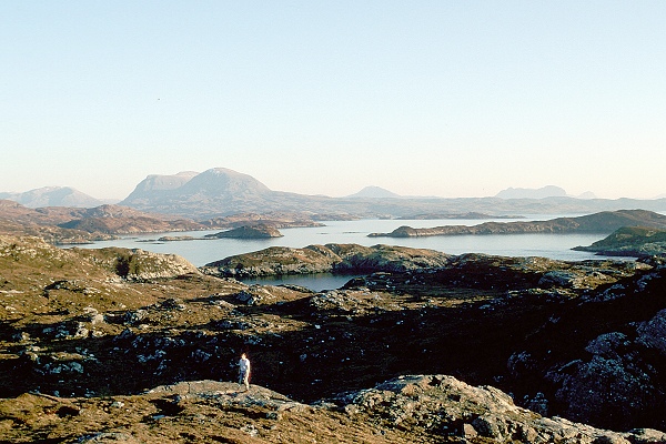
![]() This is the view south from a vantage point near Scourie.
It shows the typical undulating rocky landscape of the
Lewisian gneisses. In the distance the mountains that rise
up above this nearly-level surface are made of Torridonian
sandstones lying on top of the gneiss. The present-day land
surface at the base of the mountains almost coincides with
the old land surface that developed on the Laurentian
continent 1000 million years ago.
This is the view south from a vantage point near Scourie.
It shows the typical undulating rocky landscape of the
Lewisian gneisses. In the distance the mountains that rise
up above this nearly-level surface are made of Torridonian
sandstones lying on top of the gneiss. The present-day land
surface at the base of the mountains almost coincides with
the old land surface that developed on the Laurentian
continent 1000 million years ago.
|
Ultramafic gneiss, Lewisian Gneiss Complex Scouriemore |
|
Mafic garnet-pyroxene gneiss, Lewisian Gneiss Complex Scouriemore |
|
Felsic gneiss (Scourian), Lewisian Gneiss Complex Scouriemore |
|
Pegmatite, in Lewisian Gneiss Complex Scouriemore |
On the northern side of the Scouriemore peninsula lies the cemetery. Passing beneath it and appearing in a small bay to the west is the so-called "graveyard dyke", one of the Scourie dyke suite, formed when mafic magma filled a vertical crack in the Earth's crust. It is about 40 metres wide, with vertical contacts. Its grain size varies from coarse in the centre to fine at the margins - a result of the more rapid cooling of the magma against the wall rock. Radiometric dating shows that the dyke was intruded 2000 million years ago. Dykes like this are a valuable time marker in the Lewisian Gneiss Complex. In this part of the Complex they occur as parallel WNW-ESE trending vertical sheets, with their igneous texture still visible, that cut across the folded layering in the gneisses. Elsewhere, notably north of Scourie around Loch Laxford, they have been deformed and metamorphosed. Thus, the Complex can be divided into a region where the deformation and metamorphism is older than the dykes (and is assigned to the Scourian episode) and a second region in which the older structures have been re-worked by later deformation and metamorphism (in the Laxfordian episode).

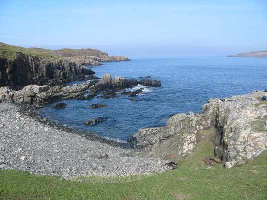
![]() The "graveyard dyke" crops out in this bay near Scourie
village. The bay is here because the dyke is less resistant
to weathering and erosion than the surrounding felsic
gneisses. On the right the vertical contact between
darker dyke rock and paler gneiss can be seen.
The "graveyard dyke" crops out in this bay near Scourie
village. The bay is here because the dyke is less resistant
to weathering and erosion than the surrounding felsic
gneisses. On the right the vertical contact between
darker dyke rock and paler gneiss can be seen.
|
Gabbro, dyke in Lewisian Gneiss Complex Scourie |
| Scourie | Achmelvich | Laxford | Clachtoll | Stoer | Assynt | Skiag Bridge | Glencoul | Knockan | Borralan | Ledmore |
| Home | Geological History | Stratigraphy | Area map | Rock Index | About |
D.J. Waters, Department of Earth Sciences, May 2003